
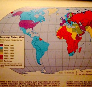
“Of the world’s current countries, only 27 were independent in 1800… more than half of the world’s countries came into being as political entities [between 1960-1989].” -The Student Atlas of World Geography
The world was a different place when my father was born. Literally, it was a different place. It is sobering to think that over half of the sovereign countries on the planet today are under 50 years old. When my father was born, they didn’t exist. A hundred countries have come into being since then.
The cartographers of the second half of the 20th century must have been busy creatures — the politicians, the soldiers and the revolutionaries, too. The birth of a country seldom comes without bloodshed.
The political world has just gone through a period of separatism — it is still separating. Ethnic groups in Spain fight for a little piece of the countryside where the people speak their own dialect; a decade ago, Quebec remained a part of Canada by a single vote; the Uighurs don’t want to be a part of China; the Tibetans want their country back; the Soviet Union fractured into pieces; and those pieces fractured into more pieces.
There are now two Koreas, two Samoas, three Guianas, a Papua New Guinea, a Congo, a Democratic Republic of Congo, and a Central African Republic. There is no way that Okinawa is culturally or geographically a part of Japan. Arunachal Pradesh is claimed by both China and India. Arunachal Pradesh claims itself. Even little Belgium is about to split up into even littler countries.
Lost in Time
What year is my map from? is a question the world traveler must ask. Where the hell did Equatorial Guinea come from? Is Western Sahara a real country? Does a country need a certain amount of surface area to be called as such? Are there any rules to becoming a country?
My 1980s Student’s World Atlas that I studied as a boy led me astray. I look at it today, and see lines and a kaleidoscope of colors partitioning the once good-looking and large mono-color regions. The sums of a country’s parts are no longer satisfied with the value of the whole. They want to be their own whole. And the parts within these parts want to be their own whole as well. And on and on.
The political world map now looks like an old Roman fresco. With each year new cracks are formed in the stucco and divides the painting further. The political map is being divided to death.
Today’s Splinterings
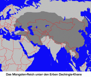
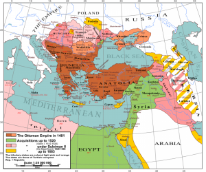
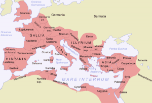
Conquest works in waves. The world was once divided into thousands of little kingdoms, fiefdoms, tribes, communities. Separated, these groups were always easy to conquer. One group would grow strong and decimate its neighbors; some spread their conquests over entire continents. A period of empire would then ensue. But soon enough, groups would again divide into smaller units; tribes would realize their differences from other tribes; and demand a fight for independence. The empire would then crumble like a Roman fresco of antiquity.
The political dispersion of the world would then break up again into little kingdoms, fiefdoms, tribes, communities. Separated, these little groups would be easy to conquer. One group would prove itself the strongest . . .
On and on.
At what point in this cycle are we in today? New countries are still creating themselves, even after the fall of rampant colonialism, separatist movements are afire all over the globe.
The closer various tribes get to each other, the more different they often think they are.
But in the middle of this tribal minimalist movement, huge blankets of political regionalism are evolving. Geographically-mandated trade and political agreements are combining the small tribes of the planet into conglomerated chunks.
The European Union is roping in all of Europe, and dropping its internal borders, using a common currency, and standing behind a similar international mask. The Free Trade Agreement of the Americas has swept Spanish America into one big free trade zone. Colonel Muammar Qaddafi talked of a single African country, where he would rule as a “king of kings;” ASEAN has brought Southeast Asia to a singular geopolitical point; while the Shanghai Cooperation Organization ties together Russia and China.
There is now an African Union, the Andean Community of Nations, the Arab League, the Association of Caribbean States, the Commonwealth of Independent States, the Commonwealth of Nations, the Francophonie, the Organization of Eastern Caribbean States, the Pacific Islands Forum, the CARICOM, OECS, OSCE, SAARC, and even an Unrepresented Nations and Peoples Organization.
As the political world fractures, it bonds anew, just to fracture and bond again.
I think of the ceramic shards that I sometimes find while doing archaeology fieldwork. Their material was once clay in the ground, uniform strats of soil that clearly lay on top of other strats formed from years of soil molecules conglomerating together and dividing apart.
Then someone scooped up a little of this clay and fashioned it into an independent unit, a clay pot. This clay pot was transported away from its primordial base, and used under new and changing circumstances. Later, inevitably, it was dropped and shattered into pieces.
Years go by, and the pieces fracture even more. Then an archaeologist finds them, collects them and takes them back to the lab. There, the ceramic shards are laid out upon a large table, and slowly pieced back together.
Soon enough the pot takes form again. You can still see the cracks in it, as the individual pieces are assembled back together with an adhesive, but the parts come together again as one whole clay pot. It is then placed on display with other similarly pieced together pots.
But I know sometime, someday, this pot will be dropped and broken into pieces once again. And I also know that someday, way in the future, the clay from this pot will disintegrate back into the nameless, unclaimed stratigraphy of the earth.
As with countries.
In Joseph Conrad’s 19th century novella “Heart of Darkness,” Africa-bound protagonist Charlie Marlow famously comments on this, in a way I think about too:
“Now when I was a little chap I had a passion for maps,” he recalls. “I would look for hours at South America, or Africa, or Australia, and lose myself in all the glories of exploration. At that time there were many blank spaces on the earth, and when I saw one that looked particularly inviting on a map (but they all look that) I would put my finger on it and say, ‘When I grow up I will go there.…” I have been in some of them, and, well, we won’t talk about that. But there was one yet the biggest, the most blank, so to speak, that I had a hankering after.”
Today those blank spaces a full of lines. For now.
Wade Shepard has been perpetually traveling the world for the past 11 years, through more than 50 countries on five continents. He writes about the people he meets, the places he visits and his impressions of how the world comes together on Vagabond Journey Geographic and Vagabond Journey Travelogue.



August 6th, 2010 at 2:30 am
Many so called “countries” do NOT deserve to be called countries.
WHY?
1. Too small
2. Economically too small to survive
3. Politically corrupt
4. Have absolutely no significance on the world scene
5. Costing the world community money
Let’s establish a stringent criteria under which a land mass can be created into a country that also has capable leaders that can actually RUN a country.
Jurgen Ankenbrand http://www.photographybyjurgen.com
August 6th, 2010 at 6:02 am
I really appreciate your questions on the political map of the world. I personally am concerned by the Morocco/Western Sahara case. In fact, when you look at worldwide maps actually you have the impression that the line dividing Morocco into two parts means that a republic is taking place in this part of the world !!! As a matter of fact, the line is definitely virtual. On the ground, there is no borders or customs. It’s the same country : Morocco. Well, there is a running conflict between Morocco and a separatist faction backed in Algeria supporting the independence of Western Sahara but it has nothing to do with the existence of the line in worldwide maps. This line exists since the 60′ when the Western Sahara was Spanish. At that time, Morocco asked the UN to consider this land as a territory to decolonize for historical legitimacy. Morocco recovered finally the territory peacefully in 1975 but nothing changed on worldwide maps. I believe the Morocco/Western Sahara case is unique in the world. I hope that one day the line will disappear to reflect the reality on the ground.
Thanks again for this initiative.
Regards
Ahmed Salem Amr Khaddad
Western Saharawi
August 21st, 2010 at 2:23 am
Politics is a “nasty” business and rarely follows what’s best for the people.
Let’s face it”
Polititiansd have one goal to pursue and that is to get “re-elected” for another term.
Will people ever learn this lesson and vote accordingly? I doubt it very much.